El Niño Could Ignite the 2026 Eastern Pacific Hurricane Season — What That Means for Mexico and Sonoma
Forecasters warn El Niño is likely to develop this summer, potentially fueling a far more active 2026 Eastern Pacific hurricane season — increasing named storms, hurricanes and rapid intensification risks, with major impacts for coastal Mexico and effects up to Sonoma.
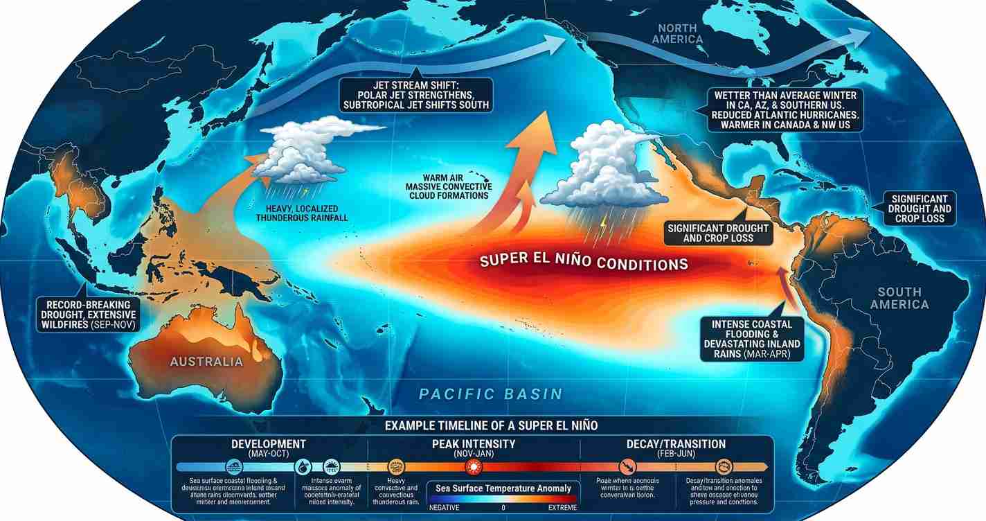
- El Niño odds: Climate models give roughly a 61% chance of El Niño forming May–July 2026, with about a 25% chance of a “super El Niño” by fall — a scenario that would push Eastern Pacific SSTs even higher.
- Mexico outlook: Mexico’s early seasonal forecast calls for 18–21 named storms, 9–11 hurricanes, and 4–5 major hurricanes in the Eastern Pacific for 2026, above long-term averages.
- Rapid intensification risk: Unusually warm sea surface and subsurface heat content plus reduced local wind shear raise the odds storms can strengthen quickly near Mexico’s coast.
How El Niño fuels Eastern Pacific storms
El Niño is a natural climate pattern marked by warmer-than-average waters in the central and eastern tropical Pacific. Those warm waters reorganize the atmosphere across the region: higher sea surface temperatures and deep warm layers boost convection — the rising motion that feeds tropical storms — and can locally reduce vertical wind shear, creating conditions more favorable for storm organization and strengthening. See the NOAA/model summaries and forecast discussion for detailed model analysis and explainer materials.
Why the Atlantic often quiets while the Pacific roars
Contrasting dynamics: In the tropical Atlantic and Gulf of Mexico, El Niño often strengthens upper-level winds, increasing vertical wind shear that tears apart developing storms before maturation. That opposite response helps explain the historical tendency for the Atlantic and Eastern Pacific to move in opposite directions during El Niño years; for further context see model and meteorologist interviews.
Warm water, deep heat and rapid intensification risk
Beyond surface warmth, deep warm subsurface layers matter: storms traveling over thick bands of warm water can strengthen quickly. The Eastern Pacific currently shows sea surface temperature anomalies of 1–3°C above average in some areas, and climate drivers such as a positive Pacific Decadal Oscillation and recent warm events have contributed to deeper heat. Those conditions raise the risk of rapid intensification, an acceleration of wind strength over a short period — Hurricane Otis (2023) remains a stark example of how fast intensification can occur in this basin. Analysis: Fox Weather analysis.
Current forecasts and probabilities
As of spring 2026 the tropical Pacific is near ENSO-neutral but many model ensembles trend toward El Niño during the peak hurricane months. NOAA and other ensembles project about a 61% chance of El Niño establishing between May and July and roughly a 1-in-4 chance of a “super El Niño” by fall, which would amplify basin-wide warmth. (Forecast summaries: NOAA/model summaries and forecast discussion; background: Time explainer on super El Niño risk.)
Mexico’s early seasonal outlook
Mexico’s National Meteorological Service (SMN) issued an early outlook pointing to 18–21 named storms, 9–11 hurricanes, and 4–5 major hurricanes in the Eastern Pacific for 2026 — numbers above long-term averages and consistent with an El Niño-influenced season. See the Early SMN outlook summary.
Timing: why early development matters
If El Niño becomes established before mid-summer, its atmospheric and ocean warming can be in place as the Eastern Pacific begins to churn, often boosting activity from June into the fall. A later onset could allow the Atlantic to see more early-season activity before the Pacific fully shifts into an El Niño-favored pattern. Model projections that favor an early onset increase the odds of a hyperactive Eastern Pacific season. (See NOAA/model summaries and forecast discussion and related analysis.)
Historical patterns and context
Since 1990, moderate or stronger El Niño years have produced above-average Eastern Pacific seasons roughly 85% of the time in meteorological analyses and seasonal model runs. Typical Eastern Pacific averages are about 15 named storms, 8 hurricanes and 4 major hurricanes; El Niño years often push those averages higher. Analysts caution that statistics are probabilities, not certainties — individual storm tracks and steering currents remain decisive.
What meteorologists will watch this season
- Sea surface and subsurface heat content across the eastern and central Pacific (NOAA/model summaries and forecast discussion).
- The Madden-Julian Oscillation (MJO), which can produce pulse-like periods of enhanced convection and storm formation (NOAA/model summaries and forecast discussion).
- Wind shear patterns across the Eastern Pacific and tropical Atlantic (Fox Weather analysis).
- Model ensemble agreement on El Niño strength and timing, including the chance of a super El Niño (Time explainer on super El Niño risk).
Forecast uncertainty and local impacts
While model agreement has nudged experts toward a higher-risk Eastern Pacific outlook, uncertainties remain. A late-forming El Niño could blunt the Pacific boost, and steering currents will determine which coastal areas are threatened. Nevertheless, a stronger and earlier El Niño raises the odds that more storms will develop closer to Mexico’s southern and central Pacific coasts, increasing hazards such as heavy rain, high surf and storm surge.
Implications for Sonoma, California
Economic impact: Sonoma’s coastal tourism, fisheries and marinas could experience indirect effects. While most Eastern Pacific storms track west or toward southern Mexico, a more active basin tends to generate larger swells that propagate northward along the Pacific coast, producing higher surf, beach erosion and impacts to coastal businesses from Mendocino down to Sonoma and Marin counties. (See ocean swell and coastal risk coverage: Fox Weather analysis.)
Political and planning consequences: Local emergency managers and Sonoma County should consider the forecast in seasonal preparedness planning even though direct landfall risk is low. Higher surf and storm-driven inland rain can exacerbate flooding and strain response resources; officials may need to reassess sandbag inventories, beach signage and evacuation routing.
Social effects and preparedness: Residents should expect increased rip current risk and unexpected large waves. Outreach in multiple languages and clear, early warnings about ocean conditions will help keep people safe. Practical steps include securing loose outdoor items, reviewing flood insurance and updating emergency kits and evacuation plans.
Reporting notes and sources
This article draws on seasonal model briefings and media reporting on El Niño and the 2026 Pacific hurricane outlook. Key sources and further reading:
- NOAA/model summaries and forecast discussion (YouTube)
- Model and meteorologist interviews (YouTube)
- Fox Weather analysis
- Time explainer on super El Niño risk
- Early SMN outlook (Wikipedia summary)
Note: Officials and residents should treat the elevated 2026 hurricane forecast for Mexico and the potential super El Niño risk as a call to prepare. Monitor official updates from NOAA, the National Weather Service, Mexico’s SMN and local emergency managers as the season unfolds.